Wednesday, November 29, 2006

More samples of topographic maps in Google Earth

I've been playing around visualizing GPS trails from the US overlaid on topographic maps in 3D and couldn't resist to post some screenshots of the Porcupine Rim trail in Moab posted by Wikiloc member hikerdave:


(click on the image to view full size)


In a previous post I explained the steps needed if you want to give it a try. Basically:

1 - While viewing a GPS trail/waypoint of your interest, click on "More Maps" and choose a map server from the list. This results in loading the overlays on the map frame.

2 - Click on "3D View" to see that view in Google Earth.

I'm happy for having this functionality in Wikiloc. I hope you enjoy it as much as I do :)

Monday, November 27, 2006

View your GPS data overlaid on topographic maps in Google Earth

With this new feature of Wikiloc, you can view your GPS tracks and waypoints overlaid on topographic maps and aerial image layers in Google Earth.

A sample screenshot follows, but if you want to check it out live:

1- Open http://www.wikiloc.com

2- Find a trail or waypoint of your interest (or take this one from Scott or hikerdave's) and click on "More Maps" from the upper-right section of the map. Choose the map server you like from the list.

3- Now simply click on "3D View" next to the "More Maps" button to view that scene with the same base map/imagery but this time in 3D with Google Earth.


The sample below shows a mountain bike ride on 1:50000 topographic maps from ICC (using EPSG:23031):


In this previous post I wrote about how you can visualize your GPS tracks and waypoints on USGS topographic maps (in 2D with Google Maps). From now on the base map you're visualizing in Wikiloc (2D) will be rendered too in Google Earth when you open the 3D view.

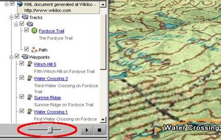
Btw: you can control the transparency degree of these layers with the slider that appears on the sidebar of Google Earth:


 Add to del.icio.us

Thursday, November 16, 2006

Minimaps

During the development of Wikiloc I've got inspiration from many web sites; one of them is Panoramio, that immediately caught my attention for its clean and usable interface.

I met with Joaquin during the Google Maps mashups contest party held two months ago in Madrid and recently I met with his partner at Panoramio, Eduardo. Put it simple, they're great people doing great stuff.

Their idea of showing a minimap on external websites with pictures of Panoramio lead me to develop the same in Wikiloc to let users display a minimap on their site/weblog with GPS tracks and waypoints

And since a minimap is better than thousand words, here are some of my pictures in Panoramio:


And here is one of my mountain bike rides in Wikiloc:


There're more and more people that have already found these kind of minimaps as an easy and cool way to complement their weblog posts. Some examples of Panoramio/Wikiloc members:

Alex Casteleiro uses minimaps from both sites in his weblog.

And so does JM Matute in his weblog.

Regarding GPS trails and as you can easily realize by visiting their weblogs, detailed information like descriptions, pictures and even videos, fit better in the website or weblog of the trail author than in Wikiloc. In this cases, Wikiloc can be seen as a search engine to find a trail, and then navigate away to the author's website where you'll get all that additional information, including a minimap :)

Wednesday, November 08, 2006

Convert your GPS files to GPX format

Update: There's no need to convert your GPS files to GPX before uploading your trails to wikiloc. From now on most GPS data formats are recognized automatically. Hope this new feature will save you some time.

--Jordi