Wednesday, November 29, 2006

More samples of topographic maps in Google Earth

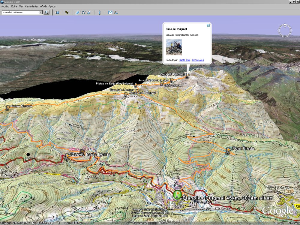
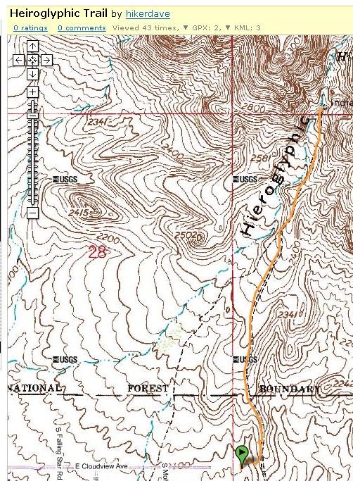
I've been playing around visualizing GPS trails from the US overlaid on topographic maps in 3D and couldn't resist to post some screenshots of the Porcupine Rim trail in Moab posted by Wikiloc member hikerdave:


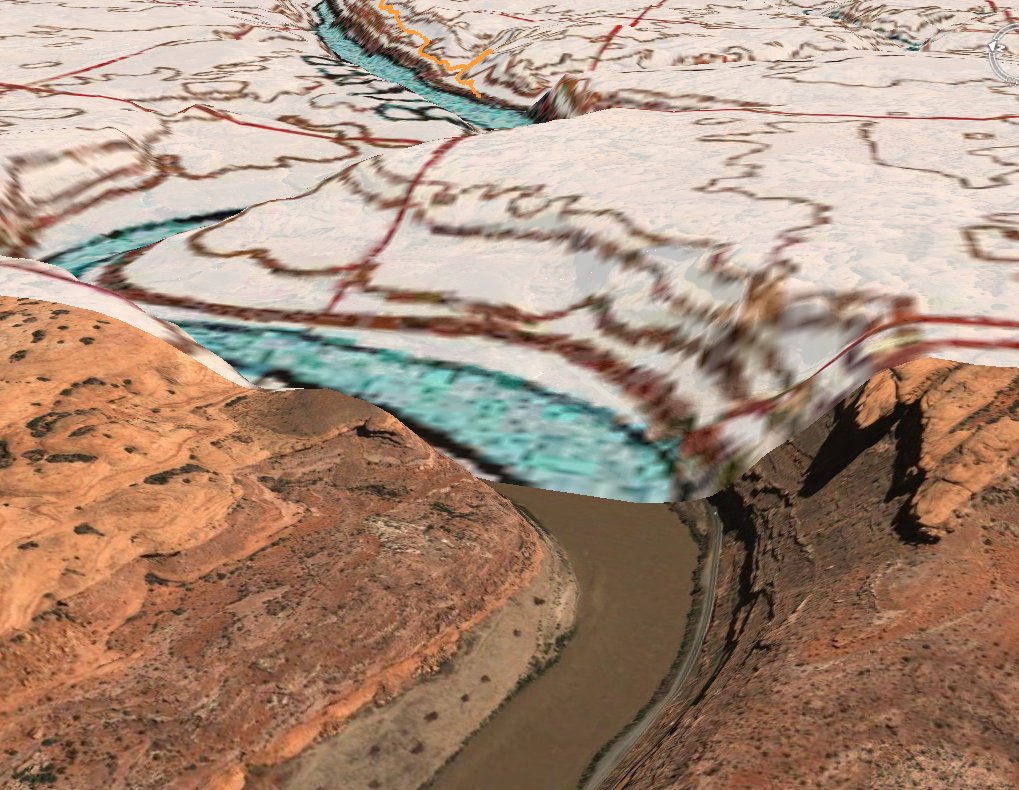
(click on the image to view full size)


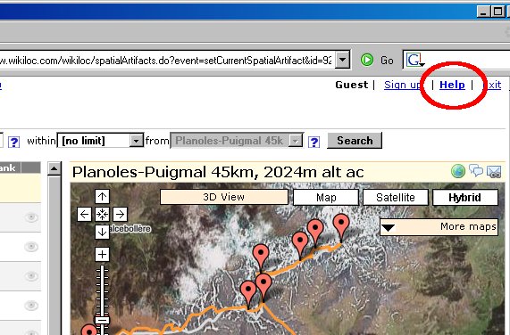
In a previous post I explained the steps needed if you want to give it a try. Basically:

1 - While viewing a GPS trail/waypoint of your interest, click on "More Maps" and choose a map server from the list. This results in loading the overlays on the map frame.

2 - Click on "3D View" to see that view in Google Earth.

I'm happy for having this functionality in Wikiloc. I hope you enjoy it as much as I do :)

Monday, November 27, 2006

View your GPS data overlaid on topographic maps in Google Earth

With this new feature of Wikiloc, you can view your GPS tracks and waypoints overlaid on topographic maps and aerial image layers in Google Earth.

A sample screenshot follows, but if you want to check it out live:

1- Open http://www.wikiloc.com

2- Find a trail or waypoint of your interest (or take this one from Scott or hikerdave's) and click on "More Maps" from the upper-right section of the map. Choose the map server you like from the list.

3- Now simply click on "3D View" next to the "More Maps" button to view that scene with the same base map/imagery but this time in 3D with Google Earth.


The sample below shows a mountain bike ride on 1:50000 topographic maps from ICC (using EPSG:23031):


In this previous post I wrote about how you can visualize your GPS tracks and waypoints on USGS topographic maps (in 2D with Google Maps). From now on the base map you're visualizing in Wikiloc (2D) will be rendered too in Google Earth when you open the 3D view.

Btw: you can control the transparency degree of these layers with the slider that appears on the sidebar of Google Earth:


 Add to del.icio.us

Thursday, November 16, 2006

Minimaps

During the development of Wikiloc I've got inspiration from many web sites; one of them is Panoramio, that immediately caught my attention for its clean and usable interface.

I met with Joaquin during the Google Maps mashups contest party held two months ago in Madrid and recently I met with his partner at Panoramio, Eduardo. Put it simple, they're great people doing great stuff.

Their idea of showing a minimap on external websites with pictures of Panoramio lead me to develop the same in Wikiloc to let users display a minimap on their site/weblog with GPS tracks and waypoints

And since a minimap is better than thousand words, here are some of my pictures in Panoramio:


And here is one of my mountain bike rides in Wikiloc:


There're more and more people that have already found these kind of minimaps as an easy and cool way to complement their weblog posts. Some examples of Panoramio/Wikiloc members:

Alex Casteleiro uses minimaps from both sites in his weblog.

And so does JM Matute in his weblog.

Regarding GPS trails and as you can easily realize by visiting their weblogs, detailed information like descriptions, pictures and even videos, fit better in the website or weblog of the trail author than in Wikiloc. In this cases, Wikiloc can be seen as a search engine to find a trail, and then navigate away to the author's website where you'll get all that additional information, including a minimap :)

Wednesday, November 08, 2006

Convert your GPS files to GPX format

Update: There's no need to convert your GPS files to GPX before uploading your trails to wikiloc. From now on most GPS data formats are recognized automatically. Hope this new feature will save you some time.

--Jordi

Thursday, October 19, 2006

Spain's topographic maps

From the beginning of Wikiloc there's been external map servers available for the region of Catalonia (North-East of Spain) thanks to the initiative of the Institut Cartografic de Catalunya to open their web map services and geodata to the public. Later on I added the Terraserver-USA Web Map Services (topo/imagery) for the United States.

Today I'm glad to announce that there's already coverage for the whole spanish territory thanks to the IDEE project of the Instituto Geografico Nacional. Their web map services have been around for quite a long time, it was my fault (lack of time!) not to made them available within Wikiloc until now.

I'm glad that the public sector in Spain is opening access to geodata to citizens, freely, interoperable, useful. Good.

I'll do my best to add all the web map services that many of you have been requesting! Stay tuned! :-)

As usual, if you want to activate additional base imagery and maps for the region you're viewing, you can do it by clicking on the "More Maps" drop down list:

Tuesday, October 17, 2006

US topographic maps

I've just added Terraserver USA Web Map Service as a provider of Topographic maps for the US in Wikiloc. Some screen captures follow but I suggest you to check it out live by yourself in Wikiloc by clicking on the links below:

Heiroglyphic Trail (Phoenix):


Rowing around Lake Union (Seattle):


Once in Wikiloc you can access these additional map servers by clicking on the "More Maps" button:

Wednesday, October 11, 2006

View your GPS data on multiple base maps

Wikiloc lets you visualize tracks and waypoints on multiple base maps, thanks to a cool feature of the Google Maps API that allows to overlay third party's map data and imagery. At the moment there's coverage for almost the whole US (using TerraserverUSA Web Map Service) and Catalunya (Spain) using the multiple WMS servers provided by ICC (Institut Cartogràfic de Catalunya). I've already received requests to add new WMS to Wikiloc and I hope they'll be available in the next few days.

Some samples:

The following images taken from Wikiloc show views of the same GPS track over different base imagery and maps. From left to right, top to bottom: Google's Map view, Satellite view (the zone doesn't have much detail by now), ICC's 1:50000 WMS topographic map and the last two pics show the detail that can be reached using the ICC's 1:5000 accurate orthoimagery (it's been taken from a plane instead of a satellite):


And another sample: the following snapshots show some waypoints taken in the way up to Mount Marathon (Seward, Alaska). In this geographic location we can use USGS imagery:


I'm personally glad of this feature since viewing my GPS tracks over multiple base maps was one of the motivations that drove me to develop Wikiloc. By then I couldn't imagine that I'll be viewing them -easily- in 3D as well. :) Hope it'll be useful for you too!

Saturday, September 30, 2006

Wikiloc gana el concurso de mashups de Google Maps España

Wikiloc está de enhorabuena ya que ha sido seleccionado como mejor mashup hispano de Google Maps en la fiesta organizada por OJOBuscador y Google Maps España celebrada el pasado jueves en Madrid.

Fué un placer estar en la fiesta y sobretodo conocer en persona a quien hay detrás de los mashups, a los miembros de la organización y distintas personalidades que asistieron al evento.

Con esta iniciativa, OJOBuscador y Google Maps España ofrecen una gran oportunidad a desarrolladores que han materializado una idea, muchas veces con mas ilusión que recursos.

Estoy recibiendo un montón de sugerencias que espero incorporar próximamente y poder continuar mejorando la aplicación.

Gracias a todos por confiar en Wikiloc!

Jordi

Saturday, September 02, 2006

Back from holidays with some improvements

During my summer holidays I've been adding some new functionality to Wikiloc. Here's the most relevant improvements:

  • Geocoding. You can find tracks and waypoints within a radius from an address or a known place worldwide. I've used the geocoding capabilities of the Google Maps API.

  • Driving directions. You can get driving directions to the start of tracks or points of interest (using Google Maps routing). That way you can get a detailed guide to arrive by car to the start of routes or points of interest and start your hike/ride from there.
  • Support for very detailed GPS tracks. From now on tracks with many points draw fast and without freezing your browser. Wikiloc serves some tracks of near 5000 points; and this is not a limit at all. So you can adjust the settings of your GPS receiver to record tracks at its highest accuracy :-)
  • Performance improvements:

    The response times drawing pages are better since now data is pulled from the server on demand when you first access it. For example, the content displayed on the information windows that pop up when you click on a location on the map are populated this way.

    In-browser geometry caching. When you fetch a track by clicking on the eye icon, the geometry is displayed and stored in a local cache. Later on if you turn it off/on again it won't need to be fetched from the server again.

  • Your data is safer. I'm running daily backups instead of weekly.
  • Many little fixer uppers that are not worth mentioning here but I hope will make your Wikiloc experience better.

What I have in my 'to do' list:

  • Improve the search / zoom behavior. Including a kind of auto-search-on-pan-or-zoom feature.
  • Add a “questions to the author” message thread for each location (to start conversations like 'hey, is this walking trail cyclable?', 'are there bears in the zone?')
  • Show news and important messages on the home page. I'm thinking in pulling the RSS feed from this weblog.
  • Weekly/monthly *optional* Email alerts to authors with statistics of their locations (number of views/downloads/ratings/comments).
  • The Wikiloc's Forum

Thanks to all of you that have contacted me suggesting some of those changes. Hope you'll keep sending me your feedback!

Monday, August 07, 2006

Wikiloc on TecnoMAPS.com

There's a weblog post about Wikiloc in TecnoMAPS. TecnoMAPS is a weblog about geopositioning and GIS with special interest in Google Maps and Google Earth.

Thanks to Carmen, Javier and Ignacio from Tecnomaps for the post.

Saturday, July 29, 2006

Help

During the development of Wikiloc (still ongoing) I've repeated some actions so many times that I eventually forgot that the first time I did those activities they were not so intuitive and easy to do.

I've received some emails from Wikiloc users asking for help. I've answered those emails the best I could but they've made me reconsider that some online help was needed. I've written a short document answering the most demanding questions, so check it out and let me know if you think there's something left. You can open the help page from the top right section in Wikiloc:


Or directly in this link.

Monday, July 24, 2006

Some improvements

From now on you can control the zoom level by double-clicking on the map (use the left button to zoom-in and the right button to zoom out).

Additionally I've made some improvements in the 3D view using Google Earth. You can see the images of locations and the elevation profile for tracks. I've changed the icons that represent waypoints and tracks too.

As always, I'd be glad to hear your opinion on this.

Tuesday, July 04, 2006

View your GPS locations in 3D

I've just added a button that generates a KML file (the Google Earth file format) of the location(s) that you're viewing on Wikiloc's map view. If you have Google Earth installed in your computer, you can open the downloaded file to view and 'fly around' the locations in 3D.


If the quality and detail of Google Earth's base imagery for the zone you're viewing is good, the results are pretty cool:


Friday, June 30, 2006

Wikiloc in your site

I've just added a feature to Wikiloc to help you display a dynamic mini-map of a public location on your own site. As an example, below there is a small map showing a mountain bike track with some waypoints along it that I did a few months ago:


The html code snippet you have to paste into your HTML pages to get a map like this is simply the following:

Wednesday, June 28, 2006

Wikiloc is online

It's been a long time since my last (and first) post; actually it took longer than I expected to reach this point but finally I'm glad to announce that Wikiloc is online. You can take a look at what has been my nightly hobbie for the last 5 months: http://www.wikiloc.com.

I've a long list of improvements to do, but I've decided to open the service and concentrate my work on your suggestions on how to build a better Wikiloc.

I cannot emphasize enough how appreciated is your feedback. If you wish, feel free to drop me an email or use the feedback form at Wikiloc.com.


Thanks and hope you enjoy it!