View your GPS data on multiple base maps
Wikiloc lets you visualize tracks and waypoints on multiple base maps, thanks to a cool feature of the Google Maps API that allows to overlay third party's map data and imagery. At the moment there's coverage for almost the whole US (using TerraserverUSA Web Map Service) and Catalunya (Spain) using the multiple WMS servers provided by ICC (Institut Cartogràfic de Catalunya). I've already received requests to add new WMS to Wikiloc and I hope they'll be available in the next few days.
Some samples:
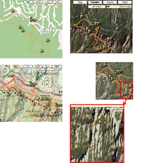
The following images taken from Wikiloc show views of the same GPS track over different base imagery and maps. From left to right, top to bottom: Google's Map view, Satellite view (the zone doesn't have much detail by now), ICC's 1:50000 WMS topographic map and the last two pics show the detail that can be reached using the ICC's 1:5000 accurate orthoimagery (it's been taken from a plane instead of a satellite):
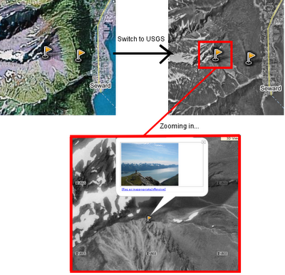
And another sample: the following snapshots show some waypoints taken in the way up to Mount Marathon (Seward, Alaska). In this geographic location we can use USGS imagery:
I'm personally glad of this feature since viewing my GPS tracks over multiple base maps was one of the motivations that drove me to develop Wikiloc. By then I couldn't imagine that I'll be viewing them -easily- in 3D as well. :) Hope it'll be useful for you too!


No comments:
Post a Comment